Many of the Hiking trips undertaken in
Trinidad lead to various waterfalls, below are a few of those waterfalls
in Trinidad. To find the
locations referred to on this page, see the Trinidad Map
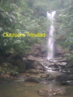
The Maracas Waterfall is situated in the upper part of the Maracas valley. To get to
the waterfall you turn from the Eastern Main Road onto Abercromby Street opposite the
Mosque in St Joseph. Abercromby Street becomes the Maracas Royal Road less than 1
kilometer from the EMR. After approximately 8 kilometers you turn onto Waterfall Road and
drive until the road begins to climb uphill. At this point on Waterfall Road there is a
car park where security and tours are provided by the participants of the National Service
program under the Forestry Division of the Ministry of Agriculture, Land and Marine
Resources.
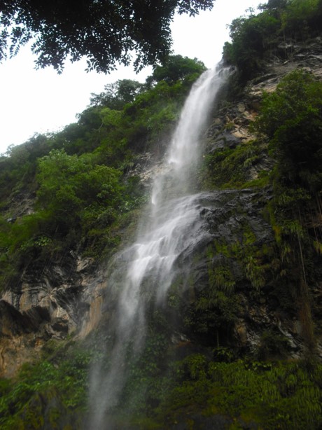
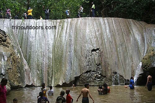
The Maracas Waterfall is a little over 91.5m. in height and is situated in cool,
beautiful surroundings. From the carpark on Waterfall Road it is a further 2.4km. to the
waterfall. The journey to the waterfall is an uphill walk along a very wide track lined on
both sides by Balata trees. After approximately 15 minutes, there is a fork in the track
and the track on the right leads to a cascade consisting of three tiers of mini waterfalls
with two large pools that are suitable for swimming.
A further 20 minutes of walking leads to the main waterfall. There is no pool for
bathing at the base of this waterfall. The water flow on the Maracas Waterfall is more
spectacular during the rainy season but even in the dry season it is a wonderful sight.
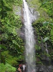
Rincon waterfall in the Rincon valley on the outskirts
of Las Cuevas on the north coast of Trinidad is a 250-foot vertical drop. The hike begins
in the valley amidst small farms, fording several crystal clear streams and then winds
uphill, culminating with a steep descent to the base of the waterfall.
The name Angel Falls conjures up visions of heavenly rapture and certainly
when one enters the forested natural setting of this area you feel a sense
of closeness with God. It is said that the name Angel was given to this waterfall because of its celestial appearance, with the
water coming out of an apparent crack in the mountain. The Angel Falls arise
from the streams that flow off the northern face of Mount El Tucuche in the
Northern Range of Trinidad. This is is a three level waterfall with small
pools that allow a refreshing bath.
There are three main routes that are used for the hike to Angel Falls; via
Maracas Valley or Las Cuevas or Zorro Trace. The hike via Las Cuevas is
approximately 14 miles with a steady uphill climb through the forest that
can take up to 3 1/2 hours to arrive at the waterfall. The route via Maracas
Valley begins in Lloango Village at the WASA pump on top of the steep hill
at the end of concrete road in Lloango Village and can take up to 2 hours to
reach the falls.
Most groups who visit Angel Falls use the route that goes via Zorro Trace.
To get to Zorro Trace one takes the North Coast Road and after Maracas and
Tyrico Bays but before Rincon and Las Cuevas Bay, there is a road on the
right (southern side) called Zorro Terrace. You enter this road and drive
until you cross two small streams, it is at the second of these streams that
the hike usually starts. The hike begins on flat terrain and then eventually
begins to ascend a hill, while the hill is not steep, it is a constant one
mile of uphill walking. At the top of the hill, one can hear the roar of the
waterfall and see glimpses of the waterfall. At this point it is a downhill
descent to the falls and the rocks in this area are very slippery, the use
of ropes for the descent aids in ensuring that there are no mishaps. The
hike to Angel Falls via Zorro Trace would usually take 1 hour.
Habio Waterfall is another of the waterfalls along the Northern Range
of Trinidad in the Rincon
valley on the outskirts of Las Cuevas. This valley
contains Rincon Waterfall, Winston Waterfall as well as
Habio Waterfall. You get to the Rincon valley by going along the North Coast Road and
turning onto Rincon Road shortly before Las Cuevas beach. Habio is the second tallest
waterfall in Trinidad and it is estimated at approximately 250 feet. The 2.5 mile trail
takes you through rich forest and involves an uphill hike followed by a long ridge walk
and then a steep downhill. The hike is rated as strenuous and takes approximately 2 hours.
The best time to see the power of Habio is during the rainy season when the water flow is
at its fullest. In the rainy season however the trail will be muddy, increasing the
difficulty of the hike. Habio is a spray type waterfall with the water hitting the black
stone backdrop and spraying out in droplets. The spray and the pounding of the water into
the pool at the base makes the area feel breezy and cool.
There are two routes that are generally used to reach to this waterfall.
A 120 minute walk through forest from the north coast village of Blanchisseuse will take you to Paria Beach. The
Paria River, which runs from the mountains of the Northern Range to the sparkling
Caribbean Sea, is a favourite with hikers because of its lovely waterfall.
The route to Paria Beach from Blanchisseusse is approximately
5 and a half miles and begins from the Spring Bridge. This
route is mainly a coastal hike that begins on a gravel road and then continues along a
forest trail. The hike is has a series of uphill and downhill portions interspersed with
beautiful views of the Caribbean Sea. During the early part of the hike you will pass two
small beaches known as Ti Delma and Laspor.
Paria Bay has a wide white sand beach that is the nesting
site for leatherback turtles. A short trail from the beach of about 15 minutes duration
leads to Paria
waterfall where there is a deep clear pool below the falls surrounded by heliconia,
fringed lilies, and philodendron.
The route to Paria Waterfall from Brasso Seco is an 8 mile
forest walk. Along the Arima-Blanchisseuse Road at the 12 1/2 mile-post,and then eastwards
for about four (4) miles (6.4 km), lies Brasso
Seco. The Paria-Morne Bleu Road and the Sansi Trace are located along this route. A
(60 degree) trail at the 4 3/4 mile-post signals the entrance to the forest. The trail is
good and clear with no turnings off, and it winds towards the north. The route takes one
past the Jordan River and over a hill. The beach is an hour away
after this hill.
The most popular starting point for this hike is along the
Blanchisseuse-Arima Road. Approximately 5 miles from Blanchisseuse
is an old agricultural road on the eastern side of the Blanchisseuse-Arima Road, bordered
by 6 pomerac trees and a chain-link fence. On entering the road you can park your vehicle
at the first house for a small fee. The road continues to the Marianne River and at the
river you turn north (left) and follow the river down stream. There is a well beaten path
that follows the river, at times crossing the river. On the last leg of the hike the path
rises up a hill. The waterfall is actually on a tributary of the Marianne River that flows
in a westerly direction and joins the main river shortly after the waterfall. The last leg
of the hike which goes up the hill is just before the joining of the two rivers and is on
the east bank of the river.
The direct hike to the waterfall is approximately 30 minutes.
Along the hike you can usually see kingfishers,
trogons,
honeycreepers and other bird life. At the base of the waterfall is a small but deep pool
that allows for an invigorating swim.
A visit to this waterfall can be combined with swimming at
the Three Pools , which is further
downstream on the Marianne River.
Mamoral Road lies off the Blanchisseuse-Arima Road between
the village of Blanchisseuse and the village of Morne La Croix. A short distance from the
Mamoral Road is Johnson Waterfall. This is an 80 foot tall waterfall that plunges into a
deep pool. Another waterfall that is a short distance from the road (quarter of a mile) is
Three Spout. Here the water has carved three separate channels and the three columns of
water fall in a row across.
Along the Blanchisseuse-Arima Road between the village of
Morne La Croix and the Brasso Seco junction, there is a road called the E1 Brasso Road.
This road leads to a waterfall that has been described by Heather-Dawn Herrera, in her
book Eco-Locations of Trinidad and Tobago, as "the most picturesque single-drop
waterfall in the area, a virtual powerhouse". This is a seventy foot waterfall that
thunders into a small pool at its base.
The Brasso Seco area has over eleven waterfalls. The Brasso Seco section of our Other Places of
Interest Page, provides directions for getting to Brasso Seco.
Sobo Falls are located in Brasso Seco and
are one of eleven waterfalls in the area. A moderately easy walk from the
village reveals this beautiful 65 foot waterfall that falls as a single flow for
approximately 25 feet and then bouncing off the rocks becomes a spray waterfall and
finally on its last leg spreads out to become a shower.
Located in Brasso Seco, just 10 minutes
walk from the Marianne Main Road is the the Twin Falls. The water divides at the top into
two streams with one part falling straight down while the other cascades in stages over
the rock into a bathing pool below. The area around the pool is suitable for lounging.
Tapana Falls are accessed by going along the Madamas Road in Brasso Seco and then
walking up the Tapana River for approximately 1.6 kilometers. The walk involves going
through a series of mini-gorges so it is advisable to have someone who knows the area and
weather to avoid being trapped in a gorge during a flash flood. The Tapana Falls are
actually a series of four (4) waterfalls. The first waterfall has a shallow pool at its
base. The second waterfall is approximately five minutes walk upstream from the first,
while the third and fourth waterfalls are a further one minute each.
The Madamas Road in Brasso Seco is used to get to the Double River Falls. The hike to
the waterfall is mainly along flat terrain with a short uphill portion. As you get closer
to the waterfall there is a downhill descent and you begin to hear and then see parts of
the waterfall through the trees. The Double River Falls are approximately 60 feet (20
meters) falling into a wide pool that is suitable for swimming.
To get to this waterfall you drive along the Arima-Blanchisseuse Road
until you see Lalaja Road, which is approximately 9.2 kilometers from the Eastern Main
Road. For those coming from Arima it would be on the right. You then drive into Lalaja
road for approximately 2 and a half miles. Drivers should proceed cautiously along Lalaja
Road as it has many "potholes" but is drivable. The hike then begins by
going along Lalaja Road and continues when the road turns into a trail. The hike to the
waterfall is mostly a gradual downhill descent crossing two streams, with only a sharp
descent as you approach the Guanapo River. On reaching the Guanapo River you walk upstream
until you encounter the waterfall. The Lalaja Waterfall is a tall narrow waterfall that
tumbles into a small pool. Although the pool is small it is possible to take a swim. As
with most Northern Range pools, the water is cold.
The hike to this waterfall can take between 2 and a half to three hours
and it is best to go with someone who has done this hike several times as it is very easy
to take a wrong turn.
Going to Sombasson Falls uses the same route as Lalaja Waterfall as these
falls lie above Lalaja Waterfall. The trek onwards to
Sombasson takes you through virgin forest and this leg is of greater difficulty. It is a
challenging hike requiring fitness and this leg can take between 40 to 60 minutes.
Sombasson Falls however has a much larger pool than Lalaja Waterfall. These falls drop 140
feet in three stages. Along the way the chirps of birds are constantly heard while the big
blue Emperor butterflies flit along the trail ahead of you.
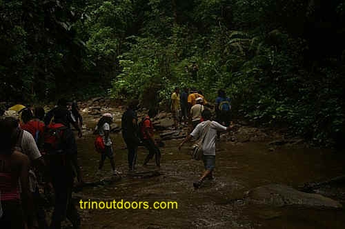
Visiting most waterfalls in Trinidad requires you to hike
for between 15 to 60 minutes, however along the Blanchissuesse-Arima Road
there is a beautiful waterfall that is completely in the open next to the
road. This lovely little waterfall is located 4.4 km from the Eastern Main
Road, along the Blanchissuesse Arima Road and is an approximately 10 minutes
drive once you turn onto the Blanchissuesse-Arima Road. This spray type
waterfall is about 25 feet high with a small pool at the base. You cannot
swim in the pool but the spray of the water gives a refreshing shower. The
water flows down a solid black face while the waterfall is backed by
towering forest trees.
The area around the waterfall is maintained by CEPEP and managed by Frank
Cole Construction Company. They have created a delightful area around the
waterfall with 2 carat sheds, one of which has benches. There is a bamboo
walkway leading to the falls and they have shrubs planted at the front and
along the walkway. This waterfall is ideal for a family picnic or as a stop
along the way to other attractions such as the
Asa Wright Nature
Center and Brasso Seco.
The trail to the Rio Seco waterfall begins on the Toco Main Road
shortly after the bridge that spans the Rio Seco river near Sally Bay. The start of the hike is sign posted on the
main road. It is possible to begin the hike at the main road or to drive approximately 2
kilometers along a country road and begin the hike further inland.
This trail winds through pathways lined by stately Mora trees along the
North Eastern coast of the island to a waterfall and deep, emerald green pool. Upriver of
the pool, on the banks of a tributary are the Rio Seco sulphur springs.
There exists an enchanting cascade within the Matura forests, whose
beauty is brought out by beautiful folds of limestone that serve as a backdrop for the
clear water flowing over the edge. Known as both the Matura Waterfall and the Manuelot
Falls, this waterfall is at the junction of the Manuelot River and the Matura River. The
water that cascades over the edge has formed a wide pool at the base that is suitable for
bathing. Getting to the falls is a challenging three hour hike that goes through Mora
forest.
Immediately before Arthur's Shop on the Toco Main Road in Rampanalgas is a street leading inland (next to the
stand pipe). To find the starting point for this hike you drive along this street until
the road goes down hill and at the bottom of the hill is an wooden house where you can
park your vehicle for a small fee. The hike begins at the southern side of that house.
There is a small stream that runs behind the house and after crossing the stream there is
a well beaten track that leads uphill. At the top of the hill you turn left and walk for
approximately 45 paces to a track on the right that leads downhill to the river. On
reaching the river, a northern (right) turn leads you upriver to the waterfall.
This is a short hike of approximately twenty minutes, without steep hill
climbs, to a two level waterfall. At the lower level the water forms a small deep pool
that is suitable for swimming and bracing as you enter. To get to the upper level there is
a narrow steep track at the side of the hill next to the waterfall pool. The upper level
also has a bathing pool. On most weekends as you approach the waterfall you can hear the
shouts of delight from the neighborhood children bathing in the pools.
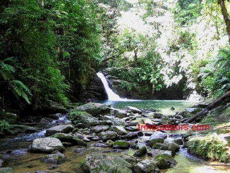
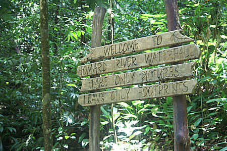
Homard River Waterfall is on the outskirts of Grande Riviere,
along the Paria Main Road leading to Matelot. Just after the 64 kilometre marker, which is
on the seaside, there is a two storey house on the left on a little incline and the trail
to the waterfall starts on the edge of that property.
The 45 minute hike to the waterfall is mostly uphill along a relatively wide path with
just a few narrow sections. In the initial part of the hike the trail ascends the mountain
in a series of switchbacks. On the final section of the trail, just before the waterfall,
steps have been cut to ease your descent to the river. Along the trail, signs have been
erected by the Forestry Division. The trail brings you out at the top of the waterfall and
there is a large sign at the river signalling the arrival at the falls.
The Homard River Waterfall is approximately 30 to 4o feet in
height with a small pool at the base for bathing. There is also a small pool at the top of
the falls that is ideal for soaking. The river is crystal clear with small crayfish
swimming in the water and while you enjoy the coolness of the water the crayfish will
sometimes nibble at your toes.
A further 25 minutes hiking upstream is Lacatang Falls, however a hiking guide is advised for going to those waterfalls.
The trail to Homard Falls is shaded by trees for most of the hike and while the trip to
the falls can be a little taxing on the leg muscles for those who do not hike, jog or walk
regularly, the return journey is truly a pleasant and enjoyable commune with nature.
There is very limited parking along the road near the entrance to the trail, so if
large group is planning to hike to this waterfall it is better to park at the car park on
Hosang Street in Grande Riviere.
The hike to these falls provides a wonderful ingredient to the
mix of a Grande Riviere visit. You can hike to the waterfall in the day then spend the
afternoon relaxing on the beach or in the Grande Riviere River and in the night watch the nesting of the leatherback turtles on the
beach.
Approximately one hour's hike upstream of the Matelot
River, along a stony river bed, can be found the Matelot Waterfall. This waterfall is
more along the size of a cascade however the joy of the visit comes from the natural
beauty of the surroundings. There is a large pool at the base of the waterfall that is
ideal for swimming.
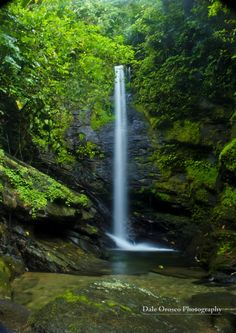
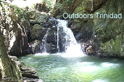
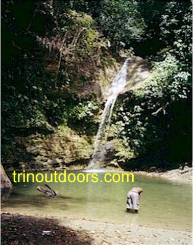
Within the forests of Cumaca lies a series of three beautiful spread type waterfalls,
where curtains of water cascade down limestone faces. These waterfalls are immediately
after each other on the Turure River. At the base of each waterfall is a pool that invites
you to take a swim. The third waterfall has several pools as the limestone forms a firm
base for the river as it flows downstream. Here the pools are of varying depth with some
being very shallow. Towards the end of the dry season the flow of water over the cascades
is greatly reduced, but there are still pools for swimming as in the photo below.
The hike to the waterfalls takes approximately 35 to 45 minutes, going through pristine
tropical rain forest. As you move along the forest trail, the calls of the bell bird can
be heard echoing among the trees. There are several river crossings and hiking in the
water along this relatively easy hike and the few uphill portions are not difficult.
Persons visiting these waterfalls should remain on the trail and not wander off, as this
area has the poisonous mappipire balsain snake especially during the rainy season.
To get to the starting point for this hike, you
proceed along the Eastern Main Road to Valencia. At the Valencia Junction you take the
left fork onto Valencia Road (as if heading to Toco). Approximately 2 kilometers along the
Valencia Road you turn left (north) onto Cumaca Road (immediately after the bridge and
before the Save the Pawi sign). The Cumaca Road is a narrow single lane road that is
mainly paved with some gravel sections. The road is bumpy in parts but passable. After 4.5
kilometers along the Cumaca Road there is a wood & metal vehicle bridge and the trail
begins on the left just before the bridge.
Many persons associate the
name Blue Basin with the waterfall in Diego
Martin but there is another Blue Basin Waterfall in Trinidad. This other
Blue Basin waterfall is located on the north-east side of the country,
quietly screened away in the village of Aripo. Aripo is a small mountain
village that lies at the foot of Trinidad’s highest mountain, El Cerro Del
Aripo (3,085 feet). The name of the village is derived from the Amerindian
word that means flat baking stone and many of the residents are descendants
of the indigenous Carina (Caribs) and Locono (Arawaks).The road leading to Aripo Village is appropriately called Aripo Road
and is on the north eastern side of the Eastern Main Road between Arima and
Valencia, approximately 8 miles east of Arima. This winding mountain road
immediately plunges you into nature when you begin your journey to the
village as the chirping of birds is heard from all around. Indeed the
Aripo Savannah
which lies at the foot of the mountains is an internationally famous birding
hotspot and near to Aripo Village in the hills, the
Asa Wright Nature
Center has bought an estate to maintain as a nature sanctuary. Along the
way to the village you see glimpses of the clear cool water of the Aripo
River and some persons visit the area simply to have a
river lime in Aripo.
The easy, 20-minute hike to the Aripo Blue Basin
Falls begins on a wide farm road that eventually narrows into a wonderful
nature trail. From here, you venture deeper into the lush green forest,
crossing many streams along the way. As you proceed you will also see many
gardens filled with produce, but please make sure the only thing you take
are pictures. Shortly after the gardens one leaves the trail and enters into
the river where a short walk will take you to the base of the falls, a
majestic limestone formation carved by nature. Similar to the
Turure Water Steps, Aripo Blue Basin Falls provide
numerous small pools to take a quick dip or to relax to your leisure. The
more adventurous ones can climb the wall and take a soak in the small pools
hidden above. This Trail description was provided
by
Caribbean Hiking Adventures
Most people associate the Caura
Valley with a
river lime and
go there to bathe in the pools, cook beside the river and generally just
relax and have fun. Very few ever venture beyond Pools 1 and 2 and when they
do it is simply to find another pool to relax in. There is however a
beautiful waterfall on the north-eastern end of the valley.
Shortly after the pools with the car parking there is a junction with a bus
stop, taking the right fork leads to a plant nursery run by Ras Shango Alamu
and one continues unto the road meets the river. The hike then proceeds
along an old dirt road until meeting an old concrete bridge which crosses a
stream. The hike route then goes left and follows the stream bed until a
fork is reached. The right fork lead to a deep narrow gorge about 30 m long
that ends at a roughly 10 m waterfall which has a shallow clear pool at its
base. The left fork leads to some small deep pools where there is clear cool
water for bathing.
Another more challenging route to the Waterfall starts in the village of
Morne La Croix and involves a walk over the mountain. The walk through the
mountain from Morne La Croix to the Caura Valley will take two and a half
hours on a wide open dirt trail.
It is recommended that for all but the simplest of hikes a guide should be
hired or arrangements made with a hiking club.
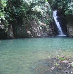
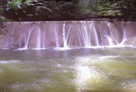
Blue Basin FallsThe name Blue Basin is given to a picturesque waterfall and
pool on the Diego Martin River. The waterfall and pool
are surrounded by luxuriant tropical vegetation
and is situated at the northern end of the Diego Martin valley. It is about nine (9) miles
from Port-of-Spain, and can best be reached by driving to an area close to the waterfall,
followed by a (5) minute walk along a bridle path. Unfortunately the area leading to the
waterfall has had crime problems so it is advisable to go to this area in a large group.
To get to Blue Basin waterfall you drive to
almost to the end of the Diego Martin valley, using either St Lucien Road or the Diego
Martin Main Road and using the North Post Road you go past the Diego Martin Museum. You then make a
right turn on Blue Basin Extension or Blue Basin Road (Blue Basin Extension eventually
joins onto Blue Basin Road) and drive almost to the end of the road. Near the waterfall
the road goes up a steep incline and you can park at the base of the incline. At this
point there are two bathing pools near the road on the right,
known as Doubla Pools. The name of these pools is
a corruption of the original French Patois name "D'eau Bleau"
which means Blue Water and interestingly is a variation of the name by which
the area is now known., "Blue Basin". From these two pools
you can follow the river
upstream to the waterfall. Alternatively you can walk up the incline and there is a path
on the right that leads to the waterfall.
The Diego Martin Valley has been a valley with green forested hillsides that
are traversed by several streams that all flow into the main Diego Martin
River. Much of the valley has retained the appearance of green hillsides,
especially the northern end of the valley and the small streams continue to
flow from the hillsides. These streams have given rise to several waterfalls
that are enjoyed by the various residents of the valley.
The best known of these waterfalls is Blue Basin Waterfall, which gets its
name from the large pool at the base of the waterfall, that is ideal for a
cool refreshing swim. A visit to Blue Basin
Waterfall allows you to enjoy a swim in the pool at the waterfall or in
the two pools that are a short distance downstream, known as Doubla Pools,
plus a short enjoyable walk up the river from the Doubla Pools to the
waterfall.
Another of the waterfalls in the Diego Martin Valley is the Bagatelle
Cascades where the water descends the hillside in a series of cascades.
Unfortunately Bagatelle has developed a reputation as an area with crime
problems and this is a disincentive for visiting these cascades.
The third and probably the smallest of the waterfalls in Diego Martin is
found at the end of Springflow Road off St Lucien Road. A visit to this
waterfall is amazing for the fact that Springflow Road is an upper middle
class neighborhood and within one minute of leaving the end of the road you
are surrounded by nature at its luxuriant best, so that you immediately
forget that the civilized world is literally seconds away. At the end of
Springflow Road, there is a narrow track and one simply has to follow the
track and within five minutes you are at the waterfall. Higher up the
hillside there are numerous small springs where the water literally bubbles
out of the ground and this water immediately begins its descent down the
hill with each trickle of water joining with its neighbor to eventually
become a small rivulet. Eventually these rivulets encounter a large 40 foot
boulder and flow off the top of the boulder to form the waterfall at
Springflow Road. The water flowing off the hillside is not sufficient to
create a pool for swimming and instead this in an area for having a natural
outdoor shower. The water when it first hits your skin feels cold but within
minutes you are enjoying its refreshing coolness. To enhance the shower
experience, nearby residents have placed lengths of split bamboo to channel
the water to create a shower away from the rock face and often when visiting
this waterfall you can find individuals bathing and followers of the
Rastafarian cult washing their locks.
The entrance to the trail to Edith Falls is on the southern
side of the road leading to the Chagaramas golf course, immediately before the golf
driving range and club house. The hike to the waterfall takes approximately 20 to 30
minutes and is very easy with only the last leg requiring about 2 minutes of clambering
over some boulders. The base of the waterfall is in the actual river bed and to get close
enough to see the waterfall you must approach near to the base, hence the reason for going
over the boulders that are in the river bed.
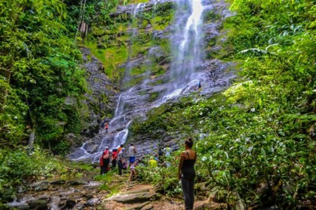
This is a three level, 250 feet waterfall that is best viewed
in the rainy season as in the dry season the water level is very diminished. When the
water level is low the flow over the falls appears like wisps or fine strands of silvery
hair.
The trail to the waterfall is fairly wide and well defined.
The initial part of the trail goes through a former tonca bean and cocoa estate. Along
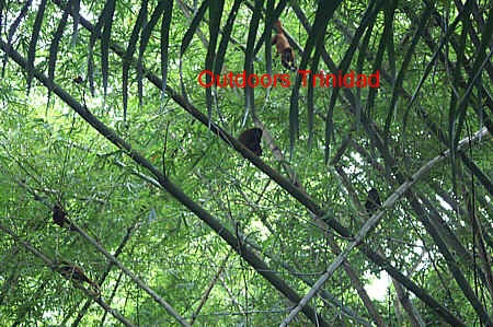
this walk you may occasionally see Red Howler Monkeys in the bamboo and the trees plus in
the evenings, Orange-winged Parrots can be seen coming to roost.
Whenever individuals think of waterfalls in Trinidad, thoughts immediately
go to the Northern Range and indeed almost all the waterfalls are found
either on the southern or northern face of the Northern Range. One exception
to this is the Carmelita Waterfall in Central Trinidad in the area of Gran
Couva. The hike to the waterfall is not long; in fact it is just a five
minute downhill walk. The difficulty is in finding the starting point for
the downhill walk.
The waterfall is just off Corosal Road, Gran Couva. To get to Gran Couva,
one takes the Couva exit off the Solomon Hochoy Highway and turns in the
direction of Preysal and Gran Couva. When you enter Gran Couva you turn
right at Police Station onto Corosal Road and proceed to a Y junction and
turn left and then around an S bend. On the bend there is a farm with 3 tall
pines trees. At the end of the fence for that property is the start of the
trail. There is galvanized sheeting at the end of the fence and a bamboo
patch, with the trail being along the side of the sheeting. Some individuals
start their hike to the waterfall lower down the river along Corosal Road
and then hike up the river to the waterfall.
The Carmelita Waterfall is not a tall waterfall and in the middle of the dry
season the flow over the edge can be merely a drip. There is a pool at base
of waterfall and several other pools down river. Around the edge of the pool
is a sandy area that some persons use for having picnics.
Some Other Waterfalls
in Trinidad
Madamas Waterfall: falls into Brasso River situated in the North East
of Trinidad.
Aripo Waterfall: Wallerfield Road, North east Trinidad
All photographs (unless otherwise stated) are the property of Brian
Ramsey. None of the photographs may be reproduced without the express written
consent of Outdoor
Business Group Limited
and Brian Ramsey.