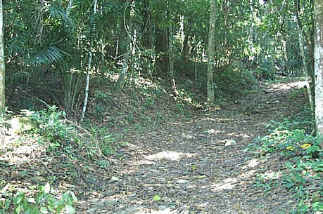
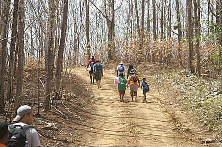
While many of the hikes lead to
various waterfalls, caves
or mud volcanos, there are many other
hiking trails to explore in Trinidad in the Caribbean. On this page we identify
some of the other hiking areas in Trinidad. To find the locations referred to on this
page, see the Trinidad Map.
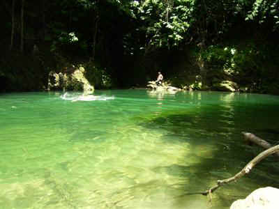
The Mermaid Pools, also known as the Matura Basin, lie along the Matura
River in north-east Trinidad. In this region the river meanders through lush pine forest
creating numerous pools that are ideal for swimming or simply relaxing alongside. The hike
to the pools is rated as easy and begins along the Toco Main Road in Matura. On entering
the Matura area you drive past the Geriatric Nursing Home for quarter of a mile and then
turn left into Thomas Trace, which is immediately before the Health Center. You then drive
for a further quarter of a mile to the areas for parking the vehicle and the start of the
trail. (Directions provided by Hikersworld). The hike to the pools is along
a forest trail and is approximately two miles which can be covered in 30
minutes. From the start of the hike it is a very gradual descent down to the
the river and then you hike along and in the river to the pools. While there
are numerous pools in this river, there are three pools in close proximity
that have developed the name, the Mermaid Pools.
One interesting facet of this exploration is why are these pools called
“the Mermaid Pools”? According to the Angelo Bissesarsingh Virtual Museum,
in West Africa and parts of East Africa there is the legend of a half-fish
half-human female water creature that is highly respected where she is
feared and worshipped as the protector of the waters of the oceans,
presenting a balance between dark, divine, mysterious and angelic
existence.
It is believed that the African slaves who came to Trinidad brought this
legend with them and the creature’s name was Mami Wata. It is further
believed that among the Matura villagers stories are told of Mami Wata coming
to the shore of this pool every now and then to deceive men and capture them
to be taken in the water kingdom. The captives are used to appease her
sexual satisfaction and then left lifeless to be buried by the living or
their bodies are never found. Over time the name Mami Wata became Mermaid as
both names describe a female creature that is half human and half fish.
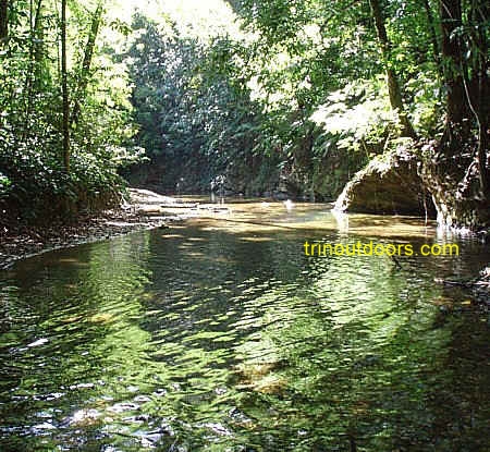
The 32 kilometer trail from Blanchisseuse to
Matelot on Trinidad's north coast is considered a jewel. Along the hike one alternates
from unspoiled rainforest to untouched beaches. Starting from Blanchisseuse at the Spring
Bridge you encounter Paria Bay after two to three hours (depending on the hiker's level of
fitness) by trekking along dirt road and forest trail.
Our section on Beyond Blanchisseuse
provides information on the beaches along the way. Paria Bay has a wide white sand
beach that is the nesting site for leatherback turtles. A short trail from the beach of
about 15 minutes duration leads to Paria
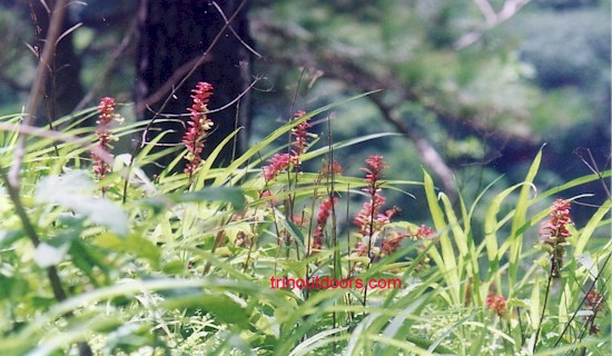
waterfall where there is a deep clear pool below the falls surrounded by heliconia,
fringed lilies, and philodendron.
If you choose to continue the hike after Paria Bay, the
trail rambles over a succession of small ridges, crossing several small streams, until you
next encounter Gran Tacarib, which is a 1.2 kilometer crescent shaped beach. From Gran
Tacarib the trail continues to the Madamas river and then Madamas Beach. Both Madamas
Beach and Gran Tacarib are nesting sites for Leatherback turtles, during the nesting
season of March to September. After Madamas it is a continuation of the up and down hiking
and crossing small streams and then the Petite Riviere river. The trail continues through
abandoned estate lands with cocoa, coffee, tonka bean, nutmeg and papaya (pawpaw) until
you arrive at the Matelot River and the village of
Matelot.
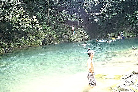
Beginning at the Spring Bridge in Blanchisseuse
it is an easy hike to the Three Pools on the Marianne River. The trail starts on the right
(eastern side) immediately before the bridge and is a short easy hike that mainly follows
the course of the river. The trails runs through secondary forest and cultivated land. The
Three Pools provide excellent swimming opportunities and there are spaces on the banks for
relaxing between swimming. A visit to these pools can be combined with a visit to the Avocat Waterfall either beginning at the
waterfall and following the river to the pools or first going to the pools and then
continuing up river to the waterfall. If the combined trip is started at the pools, there
is a short but sheer rock face that has to scaled at the last pool in order to continue up
river.
This 3.5 hour, level 4 hike has a scenic forest walk up the gentle
inclines of the Yarra forest combined with a downstream river adventure of swimming
through pools and gorges.
This river is immediately after the village of La
Fillette and at the entrance to Blanchisseuse.
The hike to Macajuel Pond is a real water adventure. Macajuel
pond lies on the Madamas River and the journey begins in the village of Brasso Seco. The
first leg of the hike is between 1.25 and two hours long depending upon where you park
your vehicles and start the hike. This portion of the hike begins along a dirt
agricultural trace running through the forest and scattered along this trace are farmer's
fields growing mainly christophene (chocho) with small wooden buildings at intervals. The
trace is undulating so there are gradual ups and downs and at intervals small streams
cross the Trace. Eventually the Trace peters out and becomes a track through the forest
ending on a tributary of the Madamas River. The hike now continues by walking in the river
until it joins with the Madamas River.
On arrival at the Madamas River one can take a short break and then
begin the climb up hill through the forest. The first part of the climb involves some root
grabbing but quickly the climb becomes an uphill walk on a track through the forest.
After approximately one hour you begin the descent to the river. This descent can
be a little tricky because the downward slope is steep but fortunately there are trees
that you can use to brace yourself as you descend. It is at this point that the water
adventure heightens.
Once on the Madamas River the rest of the journey is solely in the water. The river now
flows through a series of gorges with sheer black rock walls and you swim with the current
in the crystal clear cool water through these gorgeous gorges. At points it is possible to
walk in the water as the river bottom rises and then you swim again. At times you clamber
over logs or climb up short rock faces where the channel narrows and then jump into
the pool below until eventually arriving at Macajuel Pool. Here the river widens and
creates a deep clear pool in the river.
After enjoying Macajuel Pool it is approximately an hour's hike in a tributary of the
Madamas River to return to the point where you started your journey to the gorges. This
time the hike is against the flow of the water but the refreshing coolness of the forest
and the water makes this part of the journey seem easy. After the sloshing through the
river you retrace your steps through the forest along the agricultural trace.
The hike to Macajuel Pool should be attempted in the company of experienced tour guides or with a knowledgeable hiking
outfit.
The North Post Diego Martin to Macqueripe Chaguaramas hike offers the opportunity for
ridge hiking through natural forest, secondary forest and abandoned agricultural land
interspersed with views of the Caribbean Sea. To get to North Post, you drive to the end
of the Diego Martin Main Road, going past the River Estate Museum and then proceed up
the North Post Road to its end. The area has been called North Post because in the days of
sailing ships there was a signaling station atop the hill at the end of the road. This
station was used to send signals to Port of Spain about ships approaching Trinidad. At
present there is a telecommunications installation at the site of the former signals
station. The hike begins at this installation and there is space for limited vehicle
parking along the roadway.
The initial portion of the hike provides a clear view of the Caribbean Sea, then goes
through a pine forest, followed by semi-agricultural land. The start of the hike is just
below the telecommunications installation and on the mornings of the Great Race (a power
boat race between Trinidad and Tobago usually held in August) the area is used by many to
get a view of the boats as they race along the north coast. For those who simply desire a
short walk in cool natural surroundings with clean air, this first leg of the hike
provides that opportunity with a full view of the Diego Martin Valley and a clear view of
the Caribbean Sea. The total one-way distance covered on this hike is five miles (8
kilometers) which should take approximately 4 hours. The Trinidad and Tobago Field
Naturalists Club Trail Guide rates this hike between moderate to strenuous.
The starting point for this hike is at the southwestern side of the car park above Macqueripe Beach, with the trail leading uphill. The
length of the trail is 2.5 kilometers and provides views of the Tucker
Valley and the North Coast of Trinidad. Along the trail are leks used by the white bearded
manakin to perform their courtship dances.
During the period 1781 to 1941 the La Cuesa valley (also called Tucker valley) in
Chagaramas had several large agricultural estates growing coffee, cocoa, sugar cane,
rubber, tonka beans, coconuts, citrus. On the eastern edge of the area known as Samaan
Park there is a trail that leads to a former estate house. The entrance to the trail has
been sign posted and as you enter you realise that there are actually two trails. A wide
firm trail leads uphill to the ruins of the estate house. The trip to the house is more
like a brisk walk rather than a hike as the distance can be covered in approximately 5
minutes. The area around the house is surprisingly cool given that the forest has
reclaimed this area.
The lower trail winds around the base of the hill and at times skirts the edges of a
dry river bed. This trail leads to a former World War 2 ammunition bunker that is reached
after approximately 12 minutes. Leading away from the bunker is an old unused road that is
strewn with fallen leaves. It is therefore possible to make this into a circuit walk,
using the trail to reach the bunker and then the road to exit. The road leads to the
National Seed Center on Covigne Road, which is a short distance from Samaan Park. Those
who enjoy mountain biking will find this circuit an enjoyable, albeit short ride.
During the late afternoon hours, if you are fortunate, you may see the Capuchin Monkeys
on either the lower or upper trail as they come to feed among the hog plum trees. Even if
you do not see them you may hear them, tittering among the tree tops sounding like
puppies, or crashing from branch to branch.
During World War II when the entire Chaguaramas penninsula was a U.S. Armed Forces base, over one
million gallons of fuel was stored in underground tanks. The Lumber Lane Trail in
Chaguaramas leads past one of these former fuel storage facilities. The entrance to the
trail, which is well sign posted, is just off the Macqueripe Road (see Map)
at its southern end. The trail begins with a slight up hill walk and then continues
as a ridge walk. Along the trail there are several control valves for the fuel storage
facility. Although this area was a fuel depot during World War 2 it is now heavily
forested and several of the trees have been labeled with both their local name and their
scientific name. Part of the way along this hike, the trail divides with one section
leading to the underground tanks. The other section of the trail leads to a small picnic
area with concrete benches. At the picnic area there is a beautiful view of the
Chaguaramas coastline, the Gulf of Paria and the Five
Islands.
In late 2008, the Chaguaramas Development Authority and Nature Valley restored this
approximately three-quarter mile trail.
The Point Gourde penninsula is largely composed of limestone and the flora
is mainly xerophytic as the area has low rainfall. As such the area has mainly deciduous
woodland, merging into dry Tropical forest. Deciduous woodland is characterized by much
more open forest, with a greater proportion of deciduous trees and fewer large trees.
Mosses and epiphytes are not common owing to the greatly reduced rainfall. Prominent trees
in this area include Lonchocarpus punctatus (Savonette), Bursera simaruba (Naked
Indian), Machaerium robinifolium (Saltfish Wood) and Pithecellobium
unguiscati. Also to be seen are several species of cactus and the century plant (Agave
evadens).
To get to the starting point for the hike one travels along the Western
Main Road in Chaguaramas and then turns into the road on the left after "Anchorage
Bay" that leads to the Police Marine Division. Along that road there is a WASA
installation and immediately after is an old road that leads uphill, which is the start of
the hike. Overall this is an easy hike with two legs.
The road proceeds uphill and approximately 1 kilometer from the start there is a
relatively wide trail leading downhill on the left, while the main trail continues uphill.
This left turn is one leg of the hike. Proceeding down the left turn leads to an area that
has more lush vegetation than the rest of the peninsula with a dry gully on the right.
Eventually the trail comes to a fork with the right fork leading after a very short walk
to a sewerage plant. The left fork continues the trail. Along this portion of the hike
there are views of the sea and during the dry season the falling leaves give the feeling
of autumn in northern climates. Eventually the trail descends to an area that is well
suited to recreational rock fishing. A band
of capuchin monkeys sometimes inhabits this area.
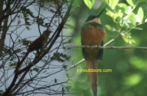
The second leg of the hike is to continue uphill after 1 kilometer from the start
instead of turning onto the relatively wide trail leading downhill on the left. Along this
leg various bird species can be seen that include Rufous-tailed Jacamars and Squirrel
Cuckoos. The trail goes past an abandoned military bunker and eventually arrives at the
top where there is a functional cell tower. Across from the cell tower there are concrete
steps that lead to an old military radio mast. Next to the radio mast is an abandoned
building and from within the building it is possible to see several of the offshore islands. There is a clear view of Carrera island and the buildings that
comprise the prison complex.
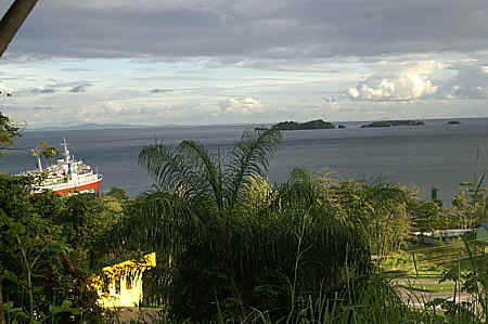
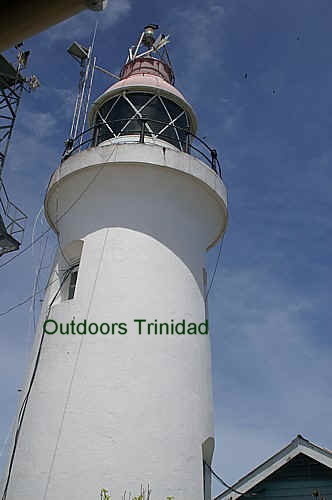
Landing by boat at Perruquier Bay, the walk to the
lighthouse takes you to the highest point on the island, 818 meters. Built in 1870, the
lighthouse is still working and is identical to the lighthouse
at Galera Point in Toco. The walk to the lighthouse is an uphill hike along a paved
road. Depending upon your fitness level the walk will take between 45 minutes and 75
minutes. During the middle of the day, there is little shade along the road so you are
exposed to the direct rays of the sun. From 1777 to 1810, cotton was was grown on
Chacachacare and along the road you can see many wild cotton plants still producing
cotton.
At the lighthouse you have wonderful views of the island, the Gulf of Paria and
Venezuela's Paria Penninsula. You can also see Patos Island, which lies further
west, and was part of Trinidad and Tobago until 1940 when it was ceded to Venezuela in
exchange for Soldado Rock.
Salt Lake on Chacachacare
Chacachacare has several attraction that are of historical interest
including the ruins of the leprosarium and the
lighthouse,
however one of Chacachacare's natural attractions that is also of historical
interest is the salt lake.
The Chacachacare Salt Lake or Salt Pond, as it is called by some, is on the
southern side of the island and is a lake that has a salinity level that is
3 to 4 times the salinity of the sea. As a result of the salinity of the
lake it is said that the original Amerindian inhabitants of these islands
would travel to Chacachacare to cut out and collect blocks of salt formed
from the evaporation of the salt water. The salt lake is next to the pebble
beach called Bande de Sud and is separated from the sea by a natural barrier
with manchineel trees. There is some debate as to how the salt lake was
formed as there are no rivers flowing into the lake. It is said that the
lake waters come from rain water that gather at this location, others have
said that there is likely to be seepage from the sea under the barrier,
while others have postulated that in times of rough seas the waves break
over the barrier and flow into the pond. It is most likely that the water in
the lake comes from all three sources.
There are several routes used to get to the Salt Pond with the easiest being
to land with a boat at Bande de Sud and then walk across the spit of land to
the lake. Another route used is to land by boat at La Chapelle Bay, and then
take a leisurely walk to the Salt Pond. A third route starts at the jetty,
at “Perriquier Bay”, and heads in the opposite direction where land erosion
is very evident. You continue around the erosion until you come to Stanislas
Bay and walk through the trees and up a little hill until you see a paved
road. You then follow the road up a very gentle incline above La Chapelle
Bay for approximately 25 minutes until you will eventually see the Salt
Pond. You continue on the road until a sudden turn off on the left has to
be taken. Once you make the left turn it is a five minute walk. If you miss
the left turn and continue along the road you will come to a dead-end.
Most individuals are aware that the original inhabitants of Trinidad were
Amerindian people who had inhabited this island long before the arrival of
Christopher Columbus. Many of the reminders of these original settlers are
in the place names throughout Trinidad or in recreations of items.
There is very little that has survived in its original construction with one
startling exception and that is the Caurita Stone with its ancient
petroglyphs. Petroglyphs (also called rock engravings) are carvings on the
face of rocks that are usually associated with prehistoric people. The
Caurita Stone is approximately six feet by eight feet and on its face are
stick figure drawings that are believed to have been created around c1000 to
1500. These etchings are thought to represent spirits or ancestors of the
Arawakan people.
pic
The Caurita Stone is located in the hills of Caurita which lies between St
Joseph and Caura in the Northern Range. Visiting this ancient artifact
requires you to go the Maracas St Joseph Valley and journey to Acono
Road and from there go on to to Caurita. The trip to the Stone involves
hiking up parts of the Northern Range. You park on a dirt agricultural
access road and then continue on foot along a dirt track. The trail winds
through cocoa and coffee estates and then enters the forest with a few small
stream crossings. As the rock carvings are up on a ridge there are some
steep uphill portions to climb, lasting around 30 minutes and in all the
hike to the stone takes approximately one hour.
The area around Mount St Benedict
has numerous trails, one of which is called the Birdwatchers Loop and takes approximately
two and a half hours. The trail begins at a building called the Sanctuary which is uphill
from the Top of the Mount parking lot. The initial portion of the trail is uphill and
takes you through a Pine plantation. About 15 minutes after the Pine Plantation there is a
fork in the trail and the right fork is the continuation of the Birdwatchers Loop. After
the fork the trail descends and ends at the steps leading to the car park at St Benet
Hall.
This trail is a good area for viewing raptors (hawks, falcons) as the updrafts in the
area encourage their soaring. Other birds that are common to the area include cuckoos,
doves, orioles and hummingbirds.
The Lopinot valley still retains much of the
natural forest cover and there are several hiking trails through the valley. One trail
leads to Colonado Cave which is named after a runaway slave who used the cave as a hiding
place. The cave has interesting geological formations. There are nine different caves in the valley, with trails leading to each. The Lopinot Tour Office and Visitor Facility
arranges tours through the area and is open from 10.30am to 3pm, Monday, Wednesday and
Friday. Tours are also available on request.
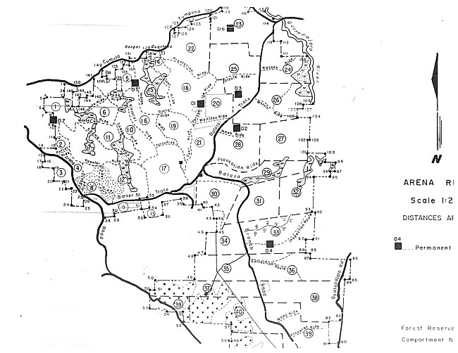
The Arena Forest in
East Trinidad has been declared a forest reserve since 1921. It is an evergreen seasonal
forest with a variety of trees including Mahoe, Guatecare, Crappa, Olivier, Matchwood and
Balata. It also contains Tirite which is used for handicraft. The Arena Forest is one of
the areas that has several hiking trails that are well suited for an easy afternoon or
early morning hike. The area consists of mainly gentle gradients and so is well suited to
family outings or for individuals who do not hike regularly but want to experience a hike
in a tropical rain forest.
As the Arena Forest is a forest reserve, the area is maintained by the Forestry Division
of the Ministry of Agriculture which has created several well marked paths through the
forest. These paths have been given some interesting names such as Deer Ride, Porcupine
Ride, Monkey Ride, Parrot Ride and Manicou Ride. Many of these paths interconnect so that
you can start on one trail and using other trails hike through the area and arrive back at
our starting point. At the end of this section is a map of the Arena Reserve showing the
trails through this Reserve.
In walking through the Arena Forest you truly experience solitude as it is a mature forest
with full grown trees on either sides of the paths. Although you have the solitude, it is
not quiet but filled with the sounds of nature; the rustling of the leaves as the wind
courses through the forest and the calls of innumerable birds. The Arena Forest is also a popular bird watching area and many
international birders visit the area each year. In the forest you can see Yellow-rumped
Caciques, Piratic Flycatchers, Squirrel Cuckoo, Plumbeous Kite, White-tailed and
Violaceous Trogons, Lineated and Golden Olive Woodpeckers, Plain Ant Vireo and
White-bellied Antbird, as well as other birds.
Arena is an Amerindian word meaning place of sand and in walking along the
paths you quickly realise that the Amerindians gave the area an appropriate name.
Throughout the area there is a layer of golden sand of the colour that you would normally
see at the beach. In hiking through this area you can also include a visit to a historical
site. Within the Arena forest, is the site of a confrontation that occurred in 1699
between the Amerindians and Spanish settlers. This event over the years has been called
the Arena Massacre and you can learn more about this event on our Other Places of Interest
Page in the Arena Amerindian Site
section.
Another activity that you can include on a trip to Arena is a visit to the Arena Dam. Along Balata Trace is an old
oil field and the wells can still be seen.
To get to the Arena Forest Reserve you turn south off the Churchill Roosevelt Highway
onto Tumpuna Road and drive for 2.1 kilometers and turn right on the road that runs along
the side of the warehouse complex. You then drive for 2.0 kilometers and turn left at the
San Rafael Catholic Church onto the Cumuto Tumpuna Road. You proceed for approximately 3.8
kilometres until you come to the Arena Plantation Office of the Forestry Division.
Map provided by the Forestry Division of the Ministry of Agriculture
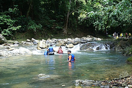
The Guanapo Gorges are an accessible series of gorges that provide an
easy yet exciting journey. Exploring the gorges with their polished rock walls that are
mirrored in the water, requires wading and swimming through crystal clear water. The
best time to visit these gorges is in the dry season as there can be flash flooding during
the rainy season, trapping you in the gorge.
Several routes are used to access these gorges with the easiest route
being via the Eastern Main Road and driving up the Heights of Guanapo Road. This route is
rated as an easy level 3 hike with an average round trip time of 2.5 hours. The second
route which is rated as a challenging level 6 hike is via the Arima-Blanchisseuse Road.
This route which begins on the La Jala South Trace has an average round trip time of 5
hours.
The Trinidad and Tobago Field Naturalist Club Trail Guide provides
excellent descriptions of both routes.
This river flows through the Valencia region in the northeast of Trinidad. Hiking along
this river exposes you to pleasant river gorge scenery and river bathing. There are two
routes used for hiking along the upper reaches of the North Oropouche River. One route
goes through the WASA compound and so requires obtaining a permit from WASA in advnce to
pass through their compound. This route is considered an easy hike as it uses a paved road
leading from the WASA compound down to the river. At the river you can then hike either
upstream or downstream but bathing is only allowed below the WASA water intake.
The other route used begins along the Valencia – Matura Road. Approximately 1.2
kilometers after the popular river lime
spot on the Valencia Road, the road turns sharply to the right and there is a gravel
road on the left. You turn onto this gravel road and drive to the top of the hill (near
the gravel quarry) where you can park. When the road is very dry you can drive further,
going downhill and crossing a stream until the road ends. At this point the hiking begins.
The hike is approximately 3 miles (5 kilometers) and is rated fair with a roundtrip time
of 3 hours. The trail leads through secondary forest with a gradual uphill climb at the
start and then a series of gentle ups and downs with some ridge walking. The last leg
before the river is a steep downhill. At the river you can turn either right or left and
there, as one person has described it, you will find "Pools beyond the imagination
that invites any nature lover to dive in for a pleasure filled swim".
The hike to Forest Point is ideal for a family outdoor activity, being more of an
extended walk with no difficult sections. Forest Point is located just south of Galera Point, Toco so the start of the
hike is on the road immediately after Salybia Beach.
The majority of the route is along semi-paved and gravel roads. The start of the hike is
on a flat road but slowly the route goes uphill, however it is a very gradual incline. As
you walk along there are views of the countryside with secondary forest interspersed with
patches of cultivated land. Most of the route is exposed to the sun but periodically the
overhanging trees provide shade along the road.
After approximately 25 minutes, you swing off the "main road" onto a left
heading dirt road. After a few minutes on this road you come to a relatively open area and
now there are a variety of trails to choose from because Forest Point is a headland area.
All the trails are relatively short and within 15 minutes you are at the shore.
The Forest Point headland has dramatic views of the ocean and on either side of the
headland there are beaches. The beach to the left of the headland (north west) is somewhat
rocky but allows for some exploring. The beach to the south of the headland (south east)
is visually arresting.
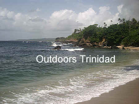
The southern beach has beautiful golden sand with a variety of
trees providing shade on the beach. The water at this beach is always clear but in August
and September it is crystal clear with exceptional visibility. One point to be noted about
this beach is that as you enter the water there is a drop of about two – three feet
and there are small smooth rocks in the water. At the eastern end of the beach there is an
area that is bounded by larger rocks that creates a natural bathing area without the drop
and a sandy footing.
If you go to Toco and ask for Forest Point it may seem as if the locals do not know of
this area and that is because the locals call the area La
Fouray. There are no lifeguards or facilities on either of these beaches.
Shark River located between Gran Riviere and Matelot is another
popular river exploration hike. Our camping page
provides additional information on Shark River.
The L' Eau Michel (pronounced Lamoshell) hike is
focused
around visiting the L' Eau Michel mud volcano. This hike is approximately one hour's
duration (one-way) along an agricultural dirt road through terrain composed of rolling
hills going through sugar cane fields and teak forest. In the dry season any hiker on this
trail should wear a wide brimmed hat and carry plenty of water (at least three bottles)
because there is no shade. More details on this hike can be found on the Natural
Attractions Page under the L' Eau Michel mud
volcano.
This hike along the south-east coast begins in Guyaguyare
at the Petrotrin Grounds. For the avid hiker the walk can probably be done in 45 minutes
but the occasional weekend hiker will most likely take 2 hours to complete the trip to the
bay. The hike begins with a short uphill segment and then continues along a virtually flat
trail ending with a short downhill descent to the bay. The thick southern forests, with
balata, silk cotton, wild chataigne, roseau, carat, and cocorite, provides a canopy that
shades you from the direct rays of the sun while along the way the mating calls of male
manakins can be heard.
Apart from the joys of being in a natural pristine environment, the other attraction of
this hike is Canari Bay. The necessity to hike to this beach or hire a boat to get there
means that this is a secluded beach far from the maddening crowd. With miles of inviting
white sands and warm soothing calm water, if the hike did not melt all the stress of daily
life, this beach will take the remnants away.
This hiking route is used by various hiking clubs so visit our Events Calendar to see the next planned hike to Canari Bay
or go to our Tour Operators Page to find a tour guide who
can provide a guided tour to this southern delight.
All photographs (unless otherwise stated) are the property of Brian
Ramsey. None of the photographs may be reproduced without the express written
consent of Outdoor
Business Group Limited
and Brian Ramsey.